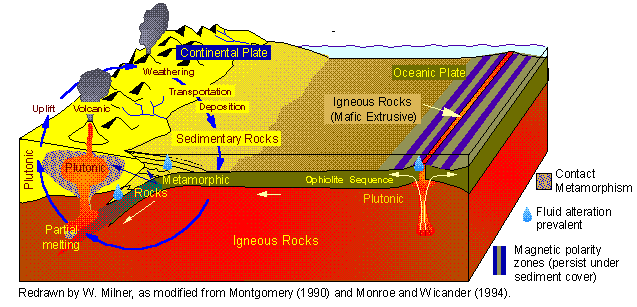
Chapter 12: Recycling the Earth's Crust
Rocks at the surface of the Earth are of many different ages, ranging from over 3 billion years old to less than 1 million years old. Because under ordinary circumstance matter can neither be created or destroyed, the new, younger rocks must have originated from older crustal material - older rocks. Older rocks are destroyed by weathering processes and the remains are recycled into new rocks. This cycle from old rocks to new rocks is called the rock cycle.
The interaction between the tectonic and the hydrologic systems causes constant
recycling of the materials of the Earth's crust. Rocks are heated, metamorphosed, melted,
weathered, sediment is transported, deposited and lithified, then it may be metamorphosed
again in yet another cycle. This recycling of the material of the Earth's crust has
been going on for billions of years, as far back as there is a preserved geologic record
(about 4 billion years). The diagram above represents the different processes
involved in the rock cycle. Weathering and erosion at the earth's surface can break
down rocks into small bits. These can be
deposited as sediments that become sedimentary
rocks. Burial, with rising pressure and temperature, can alter sedimentary (as well as any
other) rocks to form metamorphic rocks.
Continued rise in temperature can eventually melt
rocks and produce magma. Cooling of magmas leads to igneous rocks, etc.
As we have seen in preceding lectures, atmosphere, biosphere and crust are interconnected
in many ways, most importantly through the cycling of carbon. Yet
weathering of
crustal rocks does not only supply and/or consume carbon, it also provides important
nutrients without which the abundance of life would be severely compromised. While
we have seen how plate tectonics through sea floor spreading produces new crust, and
consumes old crust through subduction,
not all the rock cycling goes back into the
mantle.
Sedimentary rocks, for
example, that get piled up at the margins of the continents are not returned to the mantle
in significant quantities. Instead, when subduction occurs along that continental
margin, they get uplifted, folded up, and
thrusted, and become part of a thickened portion
of the continental crust that we commonly describe as mountain ranges or
orogens.
There, portions of them are metamorphosed, and both the metamorphosed and the
unmetamorphosed sediments are attacked by weathering, eroded, carried by rivers and
glaciers to the sea, and dumped at the margins of the continents. The next time
subduction occurs the cycle repeats itself. Whereas recycling of mantle material
through subduction and sea floor spreading does not cause a whole lot of differentiation
(what comes out is pretty much what goes back in), the
recycling of
crustal rocks across
the continents has over the eons produced a continental crust that is compositionally very
different from the oceanic crust. We have looked at the plate tectonic portion of this cycle, and also at
the associated igneous and metamorphic processes, in previous chapters.
What we will focus on in this chapter is the sedimentary part of the cycle, and how
through separating the
products of crustal
weathering, it produces chemical differentiation.
Rivers and glaciers are the main vehicles by which sedimentary materials are removed from elevated portions of the continents (mountain ranges, plateaus), and are transported to the oceans and the continental margins. Just as the large conveyor belt current in the oceans redistributes heat in the ocean-atmosphere system, so do rivers and glaciers redistribute sediments across the continents. Glaciers are very powerful erosion and transport machines, but because they only play a major role during ice ages, on an historical perspective (over the entire Earth history) they do not play an as important role as rivers.
RIVER SYSTEMS (fluvial systems)
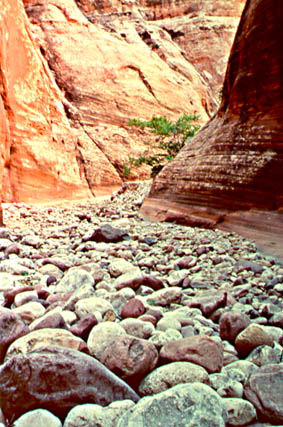
Fluvial systems are the most important dynamic system in shaping the surface of the continents. River systems drain the continents, and at the same time move weathering debris (gravel, sand, silt, mud) to the ocean basins. They are thus a main factor in the erosion (denudation) of the continents. By removing weathered materials they allow new material to be exposed to weathering, and thus aid the continued weathering of the earth's surface. They remove the rocks of rising mountain chains, promoting uplift of the root zone, and are thus involved in crustal dynamics (tectonics). All land surfaces are covered by a network of stream valleys. Even in deserts, where rain being a very short-lived episodic event (once every few years), dissection of the landscape by stream valleys is a prominent feature. Thus, wherever we go, streams are the major factor that shapes our terrestrial landscapes.
MAJOR FEATURES OF RIVER SYSTEMS:
 |
Each river consists of a main channel that is fed by tributaries, it is separated from adjacent river systems by a divide (a ridge, continental divide) beyond which water will flow to the adjacent river system. The surface of the drainage basin slopes towards the main channel, and downslope along this channel. All water and eroded sediment in the drainage is funneled into the tributaries, and finally into the main channel. |
Typically a river system can be subdivided into three subsystems:
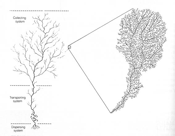
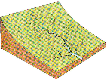
The Collection System consists of a network of small tributaries in the headwater region. There is a whole hierarchy of tributaries as the water and sediment is funneled towards the main stream. This hierarchy starts with erosional rills (inches wide, some yards long), followed by gullies (up to some feet wide), followed by creeks (up to some yards wide), streams (tens of yards wide), to major rivers (hundreds of yards to miles in width). Because as we go seawards in a drainage system the area drained increases in size, the larger members of this hierarchy will be increasingly common in the lower reaches of a river (they can carry more water), whereas the smaller ones will be dominant in the headwaters region. In most cases we can discern a dendritic (tree-like) arrangement of smaller and smaller tributaries as we go upstream. The drainage basins of rivers are separated by divides, and the same goes for the hierarchic lower members. They as well have smaller drainage areas, and are separated by divides from those of neighboring gullies, creeks, and streams. Thus we can examine many features of a river system on a small scale (say the scale of a creek), and can observe all the various features that are also characteristic of a whole large stream system. Bedrock geology will tend to influence the river pattern in a drainage basin, for example, if we have folded rocks, the river valleys will tend to be in rocks that are easily eroded (shales), and will be separated by ridges that consist of more resistant rocks (sandstones).
The Transporting System is constituted by the main stream and the major tributaries (Mississippi, Missouri), which are the main channelways through which water and sediment that is collected in the upper reaches of the drainage basin is transferred to the ocean basins. Of course, along the way these major rivers still gain additional sediment and water from tributaries further downstream. But the major contribution tends to come from the (usually) mountainous headwaters. They also will deposit some sediment in the river valley, because of decreasing slope and lesser transport power.
The Dispersion System consists of a network of channels near the seashore that redistribute the sediment into the ocean. Fine grained material (clay, mud) will be swept with the water into the basin, whereas the coarser material will be deposited at the shoreline and form a delta.
SEDIMENT TRANSPORT BY STREAMS Because of the role of rivers in erosion of the continents, they must also carry this material downstream and finally to the oceans, in order to remove it from the continents. Rivers transport erosion products in three ways:
The Suspended Load as mentioned above consists mainly of clay and silt, and is kept in suspension by the turbulence of the flowing water. It normally constitutes the largest part of a rivers load (remember, about 60% of all sediments consist of shale). Settling occurs when velocity goes to zero (enter lake or ocean).
The Bed Load of a river consists of the larger grains that are not kept in suspension by the turbulence of the flowing water. The Particles move by rolling over the channel bottom, or by making little jumps (saltation). The materials on the channel bottom stay in place until the velocity is large enough to move the particles (threshold velocity). Fluctuations in flow velocity may produce episodic sediment movement. Bed load usually does not constitute much more than 10% of a rivers total load.
The Dissolved Load signifies the dissolved salts in the river water. Most abundant are calcium and bicarbonate, followed by sodium, magnesium, chlorine, iron, and sulfate. Flow velocity has no influence (material can't settle). River water usually contains a few tenth of a percent of dissolved salts.
STREAM EROSION AND DEPOSITION
Streams remove the weathered material that accumulates on the earth's surface (the regolith/soil). The loose material is washed into gullies, the gullies merge to form creeks, from there it goes to streams and rivers. The flowing water transports the material and finally deposits it downstream (in addition dissolved load is carried). Thus the weathering blanket is removed continuously, and new bedrock is exposed to weathering.
MASS MOVEMENT AND SLOPE RETREAT As a river cuts down with its
channel the walls of the river valley become steeper and steeper, and finally
gravitational forces will be so strong to make the material move downslope in order to
reestablish a stable slope angle (angle of repose, piling up of sand and gravel, specific
slope angle for different materials). In the case that the river valley cuts into solid
bedrock the valley slopes may be very steep because of the internal coherence of the rock.
If on the other hand our stream cuts into unconsolidated material, the valley slopes will
adjust much more easily to reestablish a stable slope angle.
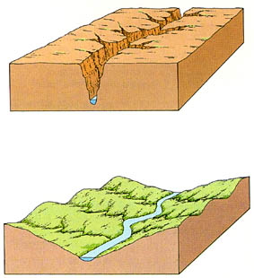 |
The resistance of the bedrock determines whether a river will cut a narrow gorge, or whether it will form a broad valley. In case of hard, resistant rock (e.g. granite, metamorphic rocks), the walls at each side will have enough strength to not collapse under their own weight. If the rock is softer, however, or lacks strength (e.g. young sedimentary rocks, mudstones), the sides of the valley will cave in due to gravitational forces. As a result, we will get a broad, V-shaped valley. |
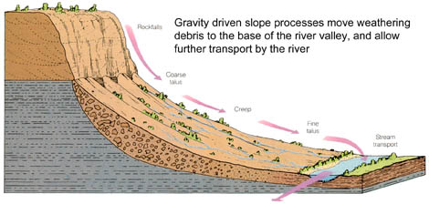 |
Gravity driven processes move weathered rock material from higher elevations into the bottom of the river valley. There the river can rework them, incorporate them into its sediment load, and carry the material further downstream. |
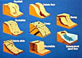 |
Illustrations of the various kinds of slope processes. Clockwise from upper left corner: Rockfall, Debris Flow, Slump/Earthflow, Subaqueous Sand Flow, Block Glide, Debris Slide, Rockslide, Creep (in center) |
| Summary Description of Slope Processes: | A) Rock Falls (free fall down cliff, of material loosened by weathering, frost
etc., forms talus) B) Rockslides (fast movements, down a fracture or bedding plane, can be catastrophic) C) Debris Slides (fast movement of weathered material [regolith, soil] downslope) D) Debris Flows (flowing mixture of fragments, mud and water, fast flow) E) Mudflows (a slurry of loose material, soil, sand, etc., and water ) F) Creep (slow movement of soil and bedrock fragments downslope, due to temperature or moisture induced expansion/contraction) G) Slumps (coherent body of rock slides downslope along a curved fault surface, develop into earth flow on the lower end) (landslides are basically large slumps). H) Blockslides (Blocks of coherent material slide over a layer of underlying plastic material) |
RIVER SYSTEMS
Eventually, all things merge into one, and a river runs
through it.
The river was cut by the world's great flood and runs over rocks from the
basement of time.
On some of the rocks are timeless raindrops.
Under the rocks are words, and some of the words are theirs.
I am haunted by waters.
From: A River Runs Through It, by Norman Maclean
 |
River systems change in character as we go from the headwaters to the ocean, because
of the influences of a variety of factors, such as:
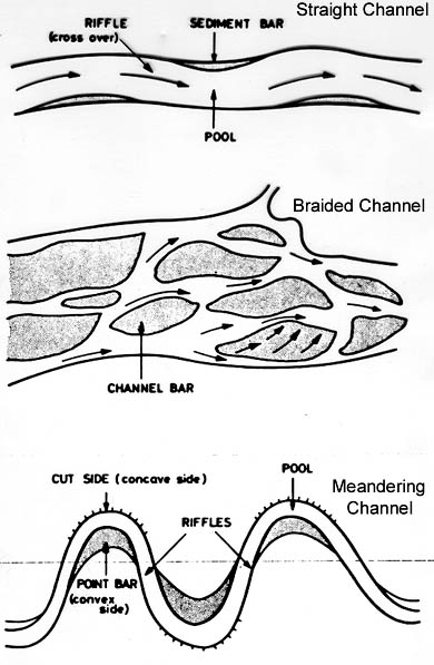
A stream can have various channel patterns (image at left), such as braided channels, meandering channels, and straight channels. These various patterns are a response to above variables, in particular the slope/gradient and the friction in the channel (related to grain sizes). |
 |
If we follow a stream all the way from the mountains to the ocean we can see changes in river morphology. The two most important variables in that respect are friction and slope. Slope implies gravitational potential and it is from this gravitational potential that the river derives its energy. As the river flows along friction against the channel walls (erosion, sediment movement) will consume this energy. If a river is in equilibrium erosion and deposition, or in other words gravitational energy gain and energy loss by friction are balanced. Thus the river will flow along with fairly uniform speed (supported by observation). If friction along a straight channel is not enough, then the downvalley flow path will increase (the river starts to meander) so that more friction work can be performed and all the gravitational energy can be used up. |
 |
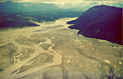
Let us now follow a river along from the uplands to the delta region (its final destination), and see how the various factors mentioned above make it change its appearance. Close to the source of a river (uplands region, left third of above diagram), when a river is still confined in a narrow valley that consists of bedrock (see picture at left), its course is largely determined by bedrock resistance. The fast flowing water will bring with it a lot of sediment, with coarse grains (pebbles) being an important component. As the stream leaves the confines of the mountain valley, the flow will spread out, slow down, and sediment will be dumped along the mountain front and will form an alluvial fan. |
 |
ALLUVIAL FANS form preferentially along
mountain ranges (called bajadas if coalescing) that were
uplifted recently, or are still
in the process of uplift, and form more commonly when there are
significant variations in
stream flow. As the sediment laden water comes from the mountain valley onto the slope of
the fan, the slope decreases, and coarse
sediment is deposited in the channels, the
channels choke with sediment, and
frequent channel shifting/abandonment occurs. Individual
channels are small (small drainage area), and bed roughness in the channel is high because
of abundant coarse particles. Thus we have
small, rough channels, and lose a lot of energy
in the channels due to friction. Therefore, even though the slope is comparatively steep (when compared with downstream sections of the river), the channels can be fairly straight and still expend all of their gravitational energy gain. Because of the choking of the channels with sediment during floods, and because of frequent channel shifting we end up with a braided stream. |
| The picture above shows coalescing alluvial fans (bajada) in Death Valley. The channel patterns on these alluvial fans are braided, the valley bottom is occupied by ephemeral lakes (playa lakes) and salt pans. Even though Death Valley is one of the hottest and driest spots in the US, the landscape is still dominated by fluvial features. |
 |
BRAIDED STREAMS require for their formation abundant supply of coarse sediment (to choke up channels), most sediment is transported in bedload, discharge is to some degree irregular (alternating floods and normal conditions cause channel choking and shifting), the river banks consist usually of loose (incohesive) material (mainly sand and gravels on alluvial fans, mud and silt is carried away). |
| To summarize, in the upper reaches of river systems we have steep slopes, abundant supply of coarse sediment, resulting in formation braided streams (with or without alluvial fans) with small individual channels and high bed roughness. | |
| In the middle portions of a river system the stream drains now a much larger area and the slope has decreased. In addition, because most of the coarse load was deposited upstream, the available sediment is finer, the river floodplain consists mainly of clay and silt, and therefore the bed roughness in the channel has decreased considerably. Because the channel will have increased its cross-sectional area (higher discharge), friction work per channel increment is lower because of the combined effects of decreased bed roughness and larger channel cross section than upstream. Along a straight flowpath, the river can not any more get rid of the energy that is imparted on it because of gravitational potential. Thus the excess energy has to be expended by an increase in channel length per downvalley distance. The stream will now flow in meanders. |
 |
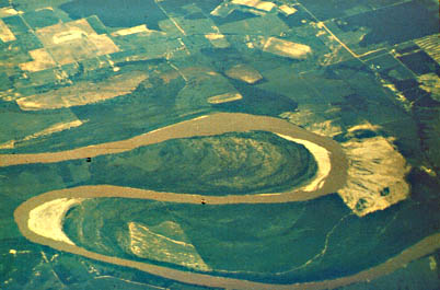 |
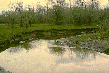
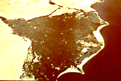
| Above picture shows a river meander closeup, with floodplain erosion on the left side. River erosion undercuts the bank and soil and floodplain sediments slump into the stream bed. Sediment deposition occurs on the point bar on the inside of the river bend. | An aerial view of a meander loop. Shows incremental addition of sediment to the point bar (latest additions are yellowish sand bars), as well as sediment spilled out from the channel during floods (sandy-yellow-brownish area at right with radiating patterns). Buildup of these spilled sands will lead to natural levees. |
| MEANDERING STREAMS require for their formation a higher component of suspended load, and less bedload than do braided stream (channels will not be choked so easily because of suspension load dominance), discharge tends to be more uniform (because larger area is drained fluctuations in precipitation and discharge are less pronounced), and their bank materials are more fine grained and cohesive. Follow this link for more information on meander formation and features of meandering streams. | |
 |
A meandering stream migrates laterally by sediment erosion on the outside of the meander (that is part of the friction work), and deposition on the inside (helicoidal flow, deceleration, channel lag, point bar sequence, fining upwards). Adjacent to the channel levee deposits build up, and gradually raise up the river over the floodplain (mainly fine sediments). If the climate is humid the floodplain area beyond the levees may be covered with water most of the time, and may form a swamp (backswamp). Rivers that want to enter the main stream may not make it up the levee, and empty either into the backswamp (filing it up gradually) or flow parallel to the stream for a long distance until they finally join (yazoo streams). Meanders may cut into each other as they grow (neck cutoffs), and then the river shortcuts (growing meanders reduce the slope, cutoffs are a means to increase the slope again, feedback loop) and the old meander is abandoned and slowly fills with fine sediment during floods (oxbow lakes). Also, as a river builds up its levees and raises itself over the floodplain, the slope and the transport power of the stream decrease, the channel fills gradually with sediment, and finally (often during a flood) the river will breach its levee (this process is called avulsion) and follow a steeper path down the valley. |
| In summary we may say that in the middle portion of a stream slopes are
moderate, channel cross-sections are large, the proportion of suspended load is high, and
bed roughness is low. As a consequence of decreased friction in the channel the channel
has to be lengthened and this is achieved by letting the river follow a curved path (the
uniform curvature of meanders ensures uniform energy dissipation along the flow path, a
smooth surface profile, and thus uniform flow; a stable configuration), the lateral
channel migration and erosion of the cut bank is where most of the gravitational energy is
consumed. Finally, when the stream reaches the regions of very low slope near the ocean (marshes, swamps, delta tops), the gain of kinetic energy by downslope movement is very small and the river has little energy left to make it to the ocean. Thus a river will choose a straight path in that case, because any meandering would result in an unacceptable energy loss. |
 |
DELTAS
are the place where the sediment that is carried by a river is
deposited in a receiving basin (be it a lake or ocean). The factors that are important for
delta building are:
|
A delta is overall a complex depositional system with many subenvironments. Follow this link to get an overview of the various environments and processes observed in the modern Mississippi delta.
|
|
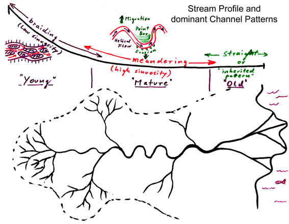
To summarize what I have told you about river systems, we may say that all boils down to the balance between friction along the flow path and kinetic energy gained from gravitational potential. The smooth concave stream profile of major rivers can be related to the interplay of those factors. When a continent or source area first emerges from the ocean, small rills will form almost immediately to carry away water and sediment. These initial rivers will have a very irregular stream profile. However, we saw that rivers tend towards uniform work expenditure along their path, and therefore the forces of erosion and deposition will work on it to smoothen the initial profile, until we end up with a concave curve as on the overhead. |
| In this curve the steepest gradients are found in the upper reaches of the
river, where sediment input is abundant, bed roughness is high, and channels are small,
because we need lots of energy to erode sediment and transport it downstream. Because of
that, channels show low sinuosity (there is no energy left to be wasted in a longer
channel). As we go away from the uplifted source we encounter
lower slopes, sediment gets
redeposited, the channel widens and bed roughness decreases. Deposition will continue
until the slope is steep enough so that a
balance between erosion and deposition is
established, and the river will then flow in meanders. Thus any irregularity in the slope
of a river will be temporary on a geological time scale. The river, its slope and its
channel patterns, will change progressively in response to the interaction of uplift, sea
level changes, and irregularities in the hardness of the bedrock. A smooth stream profile
will have been established after all forces balance. As rivers transport water and erode and deposit sediment, they sculpture those areas of the earth's surface that they flow across. The interplay between tectonic movements of the earth's surface and the continual attempt of rivers to establish an equilibrium profile leads to continuous readjustment and to continually changing landforms. We have described previously the processes of river erosion and stream valley erosion, and we will now have a look at the landscapes that develop as a result of these processes, and how we can predict landscape evolution from what we know about the behavior of rivers. Follow this link to examine the classic model of fluvial landscape evolution, developed by Davies about a century ago. |
|
GLACIAL SYSTEMS
| The earth has only recently come out of a glaciation, an ice age, which overall is a relatively rare event in earth history. Most of geologic history the earth has traditionally been characterized by a fairly mild climate. Glaciation wreaks havoc with the hydrologic system, because large volumes of water are withdrawn from the cycle and stored in ice sheets on the continents. As a consequence the sea level drops, stream flow is altered (diminished). Also, the temperature of the world ocean drops. |
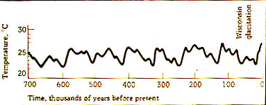 |
Paleotemperatures for the past 700,000 years (determined from oxygen isotopes in foraminifer shells of ocean sediments), record several repeated glaciations and warming periods. |
| As large ice sheets move across the continents they reshape morphology and obliterate preexisting drainage patterns. The weight of the ice sheets causes isostatic readjustments of the earth's crust. Ice sheets are very inhospitable to life, and thus large areas are depopulated and ecological equilibria elsewhere are disrupted. |
WHAT IS A GLACIER ?
| A glacier is a mass of flowing ice that forms by accumulation of snow in areas of low average temperature. Basic condition is, that more snow must fall than is lost to melting and evaporation. Transformation from snow to ice (partial melting and refreezing). Snow, planar x-tals density 0.05 or less; small spheres, firn, melting of arms, density 0.5; interlocking crystals, ice, density 0.85. After accumulation has proceeded for a number of years the ice package will be so thick, that it melts at its bottom from the overburden pressure, and flows under its own weight (thickness of 150 feet or more). Rate of flow depends on actual thickness (buildup speed), slope, and rate of melting. |
 |
This picture illustrates how a glacial ice tongue that appears to "retreat", does not actually move back uphill. The rock that is marked with an arrow is still steadily moving downhill. The ice moves downhill all the time, but what is changing over time is this: the ratio of melting vs downhill iceflow is increasing. As a net result, the icefront seems to "retreat". |
| There are basically two types of glaciers, those that form ice streams and flow down mountain valleys, and those that cover large portions of continents as contiguous ice caps. The former may have been around for most of Earth history, whereas the latter only occur when we have actual ice ages. We will discuss both types in turn. |
VALLEY GLACIERS
| Valley glaciers are streams of ice that have their origin in the snowfields of high mountain ranges. They are also called ice streams, mountain glaciers, and alpine glaciers. |
 |
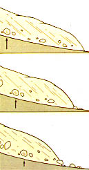
| This picture shows how from small beginnings, small ice packs in depressions, more and
more glacial erosion can result. We start at left with the formation of cirques (rounded, ice-filled depressions) and small glaciers flowing out of them, and as the climate stays cold and the ice masses grow, the landscape is gradually transformed by glacial erosion (at right). |
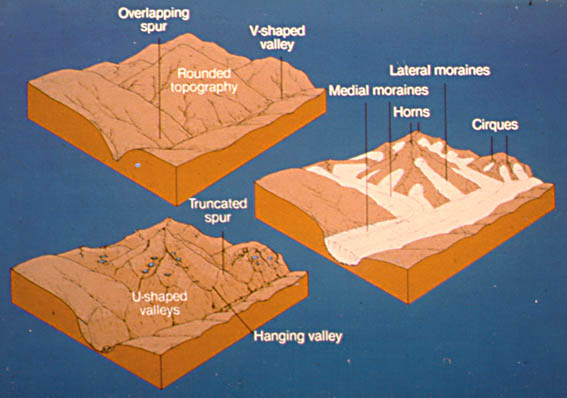 |
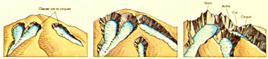
| This picture shows how an originally
fluvially produced landscape (rounded hills,
v-shaped valleys) is transformed through glaciation into a landscape with jagged topography. The newly produced morphological features (horns, cirques, hanging valleys, u-shaped valleys, and truncated spurs, are still visible long after the ice has disappeared. Follow this link to see photos and more explanation of these features. |
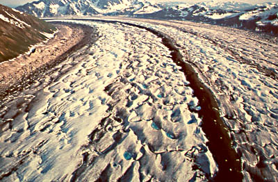
| Valley glaciers range anywhere from a few hundred meters to over 100 km in length, and move down in preexisting stream valleys. Several mountain glaciers may join together to form a larger glacier, similar to tributaries forming a large stream. Essential portions of a glacier are the zone of accumulation and the zone of ablation (ice melts and evaporates). The upper part of a glacier will behave rigid and brittle as the ice flows (formation of crevasses), and the lower part of the glacier behaves plastic. Ice continually melts away at the end of a glacier, and new ice continually moves downhill to replace it. In this process a lot of sediment is moved to the end of the glacier that accumulates as melting continues. This sediment is called glacial drift, moraines, or till. |
| Erosion by Mountain Glaciers: The movement of large streams of ice over the earth surface modifies the surface. Moving glaciers pluck out large blocks of bedrock, and carry material that moves onto them from smaller side valleys and streams. In doing their share of erosion, typical glacial landforms are produced, such as cirques, U-shaped Valleys, horns, hanging valleys, aretes (French, cirques eat into a ridge from both sides, leaving sharp sawtooth ridges), and truncated spurs. |
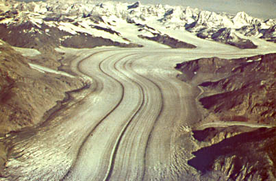 |
Photo of a large glacier in Canada that is moving down a broad valley. You can see that it has several smaller tributary glaciers that come in from the side. The strange dark lines on top of the glacier are streaks of sediment. They form when the sediment that glaciers always carry along the edge (lateral moraine, material dropped on it from the rocky slopes above) merges with the sediment from another glacier at a point of confluence (now the material is called medial moraine). When two glaciers join we get 1 medial moraine, when three join we get two, etc. The more tributary glaciers feed into a large glacier, the more stripes of medial moraine material will you see. |
| Closeup of medial moraines. They form a bit of a depression because the darker sediment has lower albedo and gets warmer than the snow and ice. Thus sediment covered areas tend to melt more. |
 |
Deposition by Mountain Glaciers:
 |
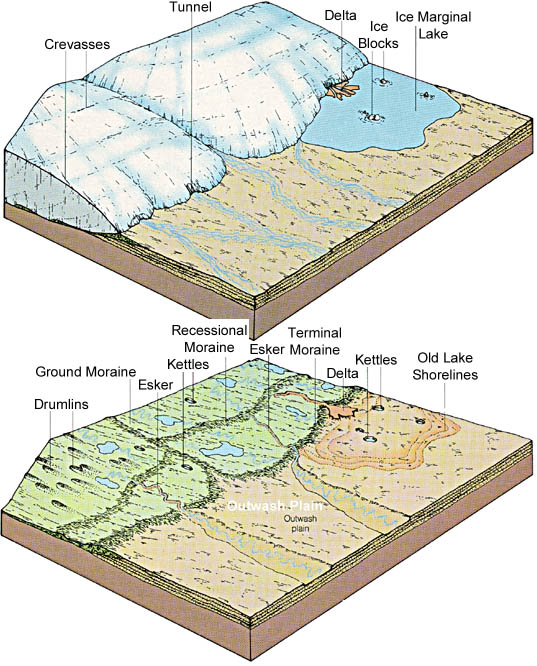
Sediment that is produced by valley glaciers is moved in a variety of ways. Most of the sediment is transported as lateral (along the side) and medial moraines (where two glaciers join), and deposited in terminal moraines in front of the glacier. A small portion of the material also forms a ground moraine beneath the glacier. Meltwater flowing from the glacier flows across the moraines and carries some of the sediment further away from the glacier, forming a so called outwash plain. Moraines mark time periods when downslope iceflow and melting were balanced, and as a result the ice front seems stationary. Because it does not move, the sediment all melts out in the same place and forms a moraine wall. The moraine that forms farthest down the valley marks the largest expansion of the glacier and is called the terminal moraine. Moraines located further upvalley mark an episode of stillstand during glacial "retreat" and are called recessional moraines. |
| Terminal moraines are usually very poorly sorted (sediment dumped from melting ice) and unstratified, whereas the water transported material of the outwash plain is better sorted and shows stratification. |
CONTINENTAL GLACIERS / ICE CAPS
 |
Continental glaciers are ice sheets, on the order of kilometers thick, that are spread
out over large portions of continents. At the present large ice sheets are found in
Greenland and Antarctica, and remnants of one are found in northern Canada.
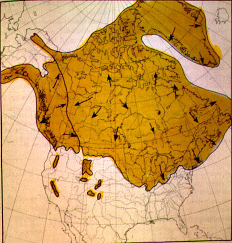
In the recent
past, the so called Pleistocene, large portions of North America and Europe were covered
by large ice sheets that profoundly altered the landscape. The picture at left shows the extent of Pleistocene glaciation in North America. Arrows indicate direction of ice movement. |
| For such ice caps to form, the climate has to cool down quite a bit. The essential parts of a continental glacier are the same as those of a valley glacier (zone of accumulation, zone of ablation, etc.). The difference between the two is, that continental ice caps are much thicker (3000 m or more), the ice movement is not downslope, but rather is a response of continually piling of snow in the central portions. The increasing pressure causes the ice mass to flow apart, and melting of the ice and sediment deposition occurs at the margins of the ice sheet. Continental glaciers also flow faster (up to 8 km per year when moving through outlet glaciers) than valley glaciers (between 90 and 200 m per year). |
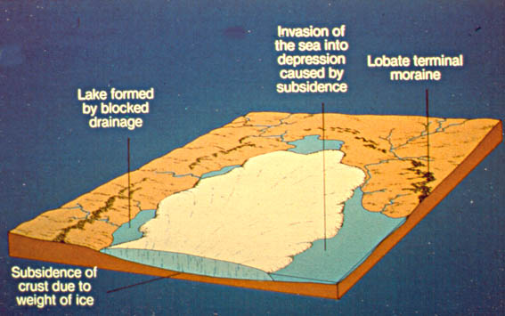 |
The weight of the ice cap causes subsidence of the crust, and ponding of water or invasion of the sea may occur against the glaciers margins because of crustal depression. Ice caps also grind up and erode the rock that they flow across, and because the pressures are so high, they have great erosive powers. This material is piled up around the ice cap in moraines (recessional and terminal). |
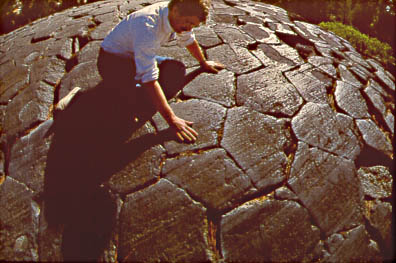 |
Erosion by Ice Sheets: Ice sheets are like a big belt sander applied to the continents, and their abrasion is manifested in glacial polish and striations (scratches). The picture shows a polished and scratched (striated) outcrop of basalt (Devil's post pile, California). |
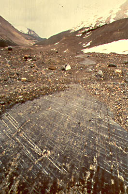
| This photo shows striations on bedrock on the valley occupied by the Athabasca Glacier (Canada). |
 |
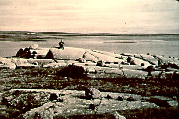 |
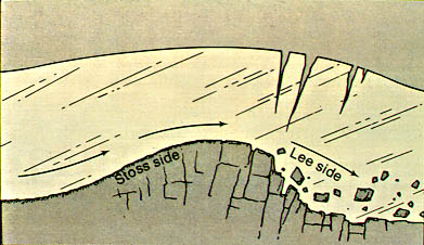
Ice sheets tend to smoothen the landscape, and original bedrock hills will be streamlined by glacial erosion. These streamlined bedrock hills (roche moutonnee) are smooth and polished on the upstream side (high pressures, ice melts) and look plucked and irregular (low pressure, ice freezes to rock) on the downstream side. |
| This picture illustrates how ice flowing over a bedrock hill causes it to become streamlined and plucked on the lee side. |
 |
Depositional Features of Ice Sheets
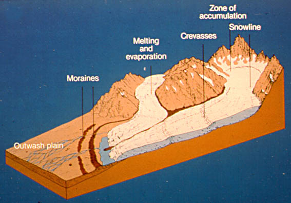
| Depositional features of continental glaciers are moraines (terminal and recessional moraines), till (moraines and outwash), loess (windblown dust). , [below ice sheet] eskers (long sinuous ridges of sand and gravel that are formed in meltwater tunnels below the glacier), ground moraine, may be shaped into streamlined hills or drumlins, and kettles (pieces of ice, left behind by retreating ice front). Glacial erosion causes striation on bedrock surfaces and creation of Roches Moutonnee (streamlining of bedrock protrusions by moving ice). Rock flour is created by crushing and grinding of bedrock, and serves as a starting material for loess. Sedimentation in lakes along the margins of glaciers is strongly variable between winter (little sedimentation) and summer (abundant sedimentation because of meltwater), and regular cyclic sediments are deposited on an annual basis, these sediments are also called glacial varves (summer layers are light and coarse grained/silt and fine sand/abundant quartz and feldspar; winter layers are finer and darker in color). These and other features are shown in the block diagram below. |
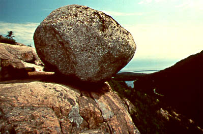 |
A large boulder that does not fit in with the other rocks around (Maine). This boulder was carried by an ice sheet from hundreds of miles away, and left here when the ice finally melted. These out of place rocks are called glacial erratics. |
| The margins of these large ice caps may extend to the shoreline of continents and the glaciers may flow directly into the sea (glacier bay in Alaska, glaciers of Antarctica and Greenland). Large blocks of ice will break off the edge of the ice sheet, and will then float on the sea as icebergs. |
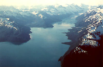 |
Large glacial valleys that were gouged out along the margins of continents as the ice sheets spilled into the sea, were later filled with water as sea levels rose after the last ice age. The are called fjords (a Norwegian word). The picture shows McCarty Fjord, Kenai Peninsula, Alaska. |
| The landforms that are produced by continental glaciers are of large extent. At the end of the glaciers sediments are deposited by moraines, but in contrast to valley glaciers that transport sediment at top and bottom, sediment transport in continental glaciers is mainly at the bottom. Where large quantities of ice have moved across all the soil is removed and the bedrock may have been eroded by several meters over very large areas. In general we can say that the intermediate and proximal areas of a continental glacier are scraped clean (roches moutonnees, striations), whereas the distal/marginal areas are characterized by till in the form of ground moraines, drumlins, eskers, moraines and outwash plains. This till covered area is characterized by a belt of hummocky hills that mark the former position of the ice margin. Iindividual moraines can be kilometers wide and 100-200 m high, and have an arcuate pattern, conforming to the margins of the ice sheet. The whole till plain may be covered with a multitude of lakes (e.g. most of Canada east of the Rockies, Minnesota, Scadinavia, in particularly Finnland). The ice sheet will also dam up rivers and cause a change of the continental drainage pattern. In many cases this drainage pattern will persist long after the glaciers has disappeared (example North American continent). Another effect of glaciation is the formation of extensive loess blankets. Loess is fine grained material, clay and silt, that is removed by strong winds from the moraines and the outwash plains, and redeposited elsewhere. The fertile soils of northern China for example have developed on a loess blanket that is in places over 100 m thick. Other large loess occurrences are in the Missouri River Valley and in Central Europe. |
CAUSES OF LARGE SCALE GLACIATION (Ice Ages)
| A period of several glaciations separated by brief periods of warming has
characterized the earth's climate for the last 2-3 million years. These glaciations ended
only about 15000 years ago, and it is a legitimate question if the period of glaciation is over, or if we just live in one of the short warming periods. At the moment,
with global warming an established fact, it looks like the period of
glaciations is over and we are in a warm (may be too warm) period for the
long haul. In any case, we can expect significant climate change in the not
too distant future. A shift to an overall warm climate (the currently most likely scenario) would lead to melting of the remaining icecaps, and a rise of sealevel by about 50-60 m. In that case many nearshore areas of continents would be drowned, and many harbour cities will disappear under water. Large portions of the Amazon basin, Southern Louisiana, Southern Texas, the Californian Central Valley, Holland, Northern Germany, and Northern Siberia would become covered by a shallow sea. On the other hand, those portions of the earth that are now covered by ice would rise out of the sea because of isostatic adjustments. Theories of glaciation are numerous.
|
If you like some poetry for the occasion, just click on the "Northern
Lights"
SHORELINE SYSTEMS
Shorelines are essentially shaped by three simultaneously acting processes:
Shorelines have for millennia been favourite places for human settlements, because of the availability of food from the sea, of drinking water from rivers, and of flat surfaces for construction of houses. However, shorelines are dynamic systems, and we have to understand the dynamics in order to plan efficiently. |
WAVE MOTION AND REFRACTION
The movement of a wave on the ocean or on a lake (a pond) does not imply the large
lateral movements of material as one might initially think, rather, waves could be
described as transplanted motion. Wave motion is the result of orbital movement of water
particles, and movement is transplanted by means of weak attractive forces between
molecules. Because of the weak attraction the particles will not move in unison, but
rather there will be a phase shift between adjacent particles. Thus, as we go along the
path of wave movement, particles will move increasingly out of phase which will cause
particles that are half a wavelength apart to move in opposite directions. Terms:
wavelength: distance between adjacent crests, wave height: vertical distance between crest
and trough, wave period: time that passes between passage of adjacent wave crests. Orbital
motion dies out at depth (friction loss of energy, energy supplied by wind drag at the
surface). The depth where movement essentially ceases is called the wave base, and is
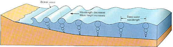
roughly half of the wave length (see below).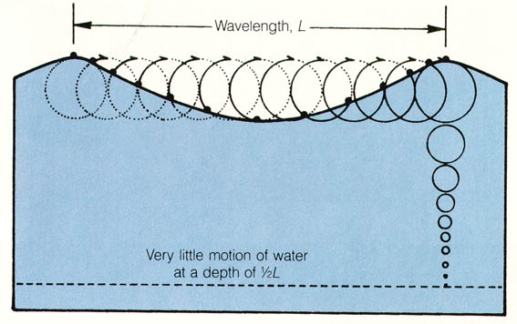 Waves form in the open ocean, many miles from any
shoreline, and when they approach the shoaling waters of the shoreline, the orbital
movement of the water molecules experiences friction with the seafloor. The wave slows
down and wavelength decreases as this friction increases with increasing proximity to the
shoreline. A result of the smaller wavelength is an increasing wave height (volume
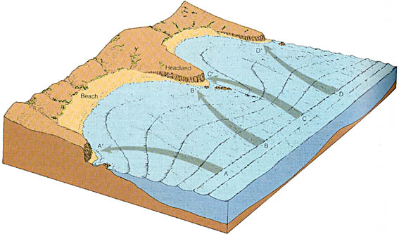
preservation, energy preservation). Slowdown of the wave is strongest directly at the seafloor, and therefore the bottom parts of the wave are slowed down more than the top portions, the wave will become increasingly asymmetrical, and will eventually topple, tip over, break, and form a breaker. At this point the energy of the forward motion of the wave is expended in a brief moment when the breaking wave rushes up the beach (surf zone), as so called swash. When the energy is expended by moving up on the beach (friction, sediment transport), the water returns seaward as backwash (see above). If waves approach the shoreline at an angle, encounter obstacles, or an irregular shoreline, wave refraction occurs. Wave refraction tends to make the wave fronts parallel to the shoreline. In the process wave energy is concentrated on obstacles to wave motion along the shoreline.
Above diagram shows how waves slow down in the shallow water in front of headlands, and move faster in the deeper water of bays. As a result, the wave front parallels the coastline and wave energy is concentrated on the headlands. The process by which waves changing direction due to bottom friction is called wave refraction. |
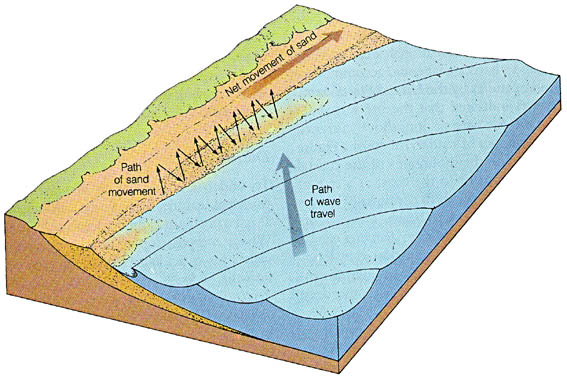
LONGSHORE DRIFT
| Longshore drift is the result of waves striking the seashore at an angle. In that
case, instead of simply moving up the beach, the water of the breakers moves diagonally up
the beach, flows back, is moved diagonally again by the next wave etc. As a result, we
have movement of water and sediment along the shoreline, a process that is called beach
drift. Because the water that flows back meets onshore moving waters, a continuous flow of
water develops, a so called longshore current that transports sediment
longshore in the breaker zone (see diagram below).
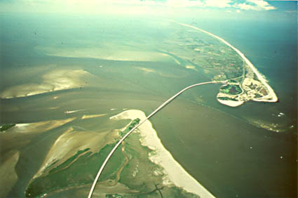
Beach drift and longshore currents constitute what is also known as longshore drift. Large volumes of sand are moved by longshore drift, and longshore drift is a major factor in the development of large portions of shorelines along the Gulf of Mexico and the North American Atlantic coast (barrier islands, lagoons, Galveston Island) |
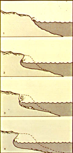
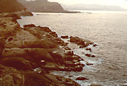
SHORELINE EROSION
The pounding of waves and the movement of sediment along the shoreline promotes
shoreline erosion. Erosion is strongest when we have shorelines consisting of cliffs, and
weakest when we have a smoothly sloping shoreline with a beach. On a gently sloping shore
the energy is expended gradually as the wave approaches, whereas in the case of a cliff
the wave may hit the cliff with full force.
Ground water moving through the rocks, frost action, wind erosion, and downslope mass movements contribute to shoreline erosion. The rate of coastal erosion depends on intensity of wave action, shoreline morphology, and strength of the bedrock. The famous white cliffs of Dover consist of chalk, a relatively easily eroded rock, and they have retreated at a rate of 2-3 m per year within historic times. |
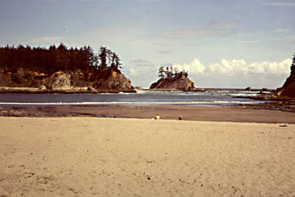
SHORELINE SEDIMENTATION
| Material that is eroded in high energy portions of a coastline will be redeposited in
low energy areas, and form a variety of features, such as beaches, spits,
tombolos and barrier islands. BEACHES consist usually of sand, but may in places also consist of cobbles and boulders (high energy beach). Beaches are usually gently inclined, and gradually absorb wave energy, pebbly beaches are steeper than sandy ones. Slope, sediment composition, and shape of beaches depend largely on the interplay between wave energy and sediment supplied to the beach. The important elements of a coastal system are the rivers that bring sediment to the shoreline so that beaches can be built in low energy areas. Another source of sediment is the erosion of cliffs and headlands. Longshore drift redistributes the sediment. Sediment can escape from the coastal system by moving landwards in sanddunes, or to the deep ocean through submarine canyons.
SPITS form where the coastline has indentations, such as bays or wide river mouths. Longshore drift deposits sand at one end of the bay opening, and forms a partial enclosure of the bay (sandbar, beach complex that grows in direction of drift). BARRIER ISLANDS are elongate, offshore islands, parallel to the shoreline, and separated from the shoreline by a lagoon and/or tidal flat (Galveston Island, Laguna Madre). They can form by drowning of beach ridges/beach-dune complexes during transgressions, and also by elongation of spits at shoreline irregularities.
TOMBOLOS form when beaches grow outward instead of sidewards. For example, of we have an offshore island, and there is less wave energy in the wave shadow behind it. Longshore drift can move sand to that area (trapped because of reduced current), and finally a sand bridge will have developed between the mainland and the island. |
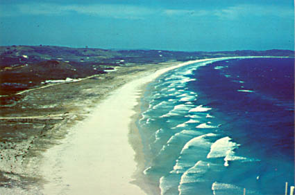
SHORELINE EVOLUTION
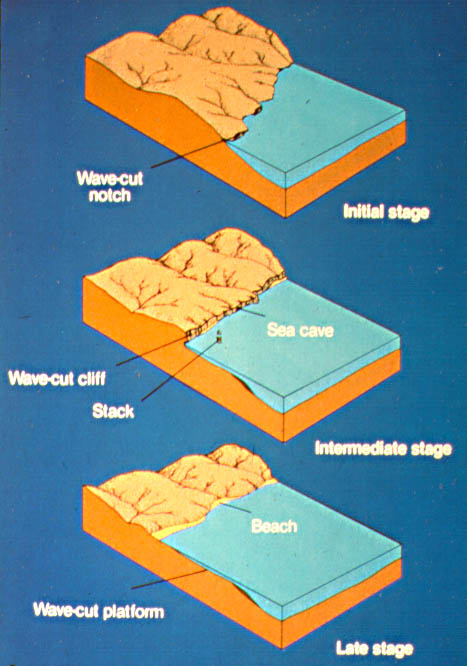
Erosion and deposition along a coast will tend to smooth out shorelines over time, and
approach what is called an equilibrium shoreline. This is known as shoreline
evolution.
Initially, when a transgression leads to a new, irregular shoreline, wave erosion will start to cut cliffs on the mainland and island shores. As time passes these cliffs grow larger and retreat, wave cut platforms grow, and eroded sediment is deposited in bays and as spits and barrier islands. Finally cliff erosion and barrier island formation have formed a straight equilibrium shoreline. |
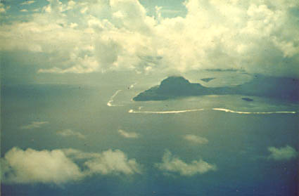
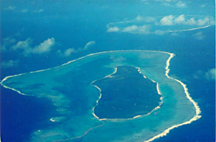
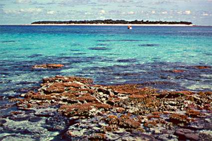
ORGANIC COASTLINES: REEFS and MANGROVE SWAMPS
Reefs are a special type of shoreline, that are build by organisms, colonial corals,
under participation of sponges, algae, and other organisms. They grow in warm, clear,
shallow water, usually in tropical regions. Terrigenous sedimentation inhibits reef
formation (disparity of sedimentation rates, turbidity reduces light penetration of
water). Wave action causes continual breakdown of reefs and skeletal material piles up on
which organisms settle and grow new skeletal structures. Important factors: marine
conditions [freshwater incursions kill organisms], requirement for light [symbiosis with
algae], warm water [supersaturation with calcite], oxygen important [wave action, food
supply, to coral polyps]. Most of the inner parts of a reef consist of piled up debris
(coral fragments, shell fragments). We can distinguish different types of reefs, such as:
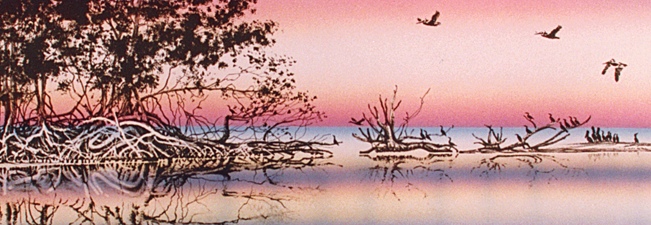
PLATFORM REEFS grow as irregular patches in shallow seas, and may in places be the result of reefs that started growing on submarine topographic highs, such as drowned shorelines or young anticlines. MANGROVE SWAMPS: Not only corals can contribute through their
constructive activities to building new shorelines and stabilizing old one's.
Mangroves, highly salt tolerant trees, also prosper along the shores of
tropical regions. Their extensive stilt-root systems serve as a baffle for sediment
that is washed through these swamps, and so lead to vertical sediment buildup and sediment
aggradation. The picture below shows mangroves and their root systems at low tide. Artists rendering of scene from Little Shark River, Florida Everglades. |
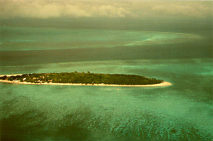
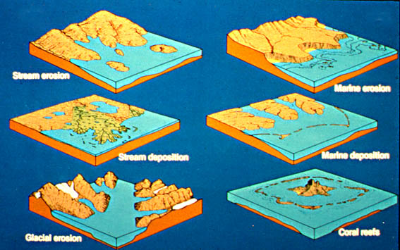
TYPES OF SHORELINES
Coastlines can be classified according to the geologic processes that helped shape
them. We distinguish:
The diagram below illustrates the various coastline types (Glacial Deposition Coast not pictured).
|
THE EFFECT OF TIDES
| Tides are produced by the combined pulling of the moon and the sun on the water cover
of the earth, and by centrifugal forces within the earth-moon system. These forces result
in the two bulges of water on the oceans. The earth rotates under these tidal bulges, and
therefore coastal areas go through two tidal cycles (ebb-flood) each day (ebb and flood 6
hours apart). The rotation of the earth moves the continents and the shorelines through the tidal bulges, and as a result tidal currents are flowing (ebb currents, flood currents). These currents depend in their strength on the tidal range, which in turn depends in shoreline geometry. The oceanic tidal bulge is only on the order of 50cm to 1 m high, and only when it runs on a sloping shore or into a bay or estuary will the water build up and form tidal ranges of up to 20 m. The tidal currents move sediment between the shoreline and the shelf, lead to the formation of linear tidal sandridges and may have a significant influence on shoreline configurations if tidal range is sufficient (spreading out of wave reworking over a much wider zone of the shoreline, accumulation of tidal mudflats).
|
TSUNAMIS
| Tsunamis are waves that are the result of sudden tectonic movements of the seafloor (Earthquakes). In contrast to surface waves, the wave motion is caused by movement of the ocean floor, and thus the whole water column is in motion (much more energy). They have long wave lengths (50-200 km), small amplitudes (30-60 cm), and the wave front travels at high speed (500-800 km/h). When these waves approach the shoreline, all the energy of motion of the deep water column is now squeezed into the short shallow water column, and as a result the wave height increases dramatically (15-30 m). Enormous destruction is inflicted on the shoreline (and any man made structures), if such a high velocity wall of water hits. |