|
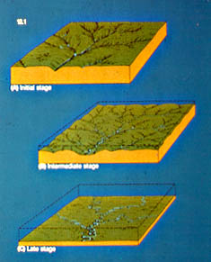
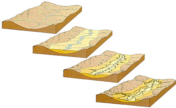
A basic model of stream erosion that goes from the young, over the mature, to the old stage of a river, under assumption of a fairly homogeneous bedrock and humid climate, was first developed by Davies about a century ago, and could be described in the steps outlined in the picture at the left. |
 |
Initial Stage During this (young) stage, a newly exposed, freshly
uplifted piece of the continent, is in the process of establishing a new drainage system.
Gradient is large (relatively high elevation), and rivers cut V-shaped valleys.
Downcutting and headward erosion are the major processes of river erosion. The divides
between rivers are broad, and exist as flat, undissected highlands between the stream
valleys. Local relief increases as stream keep deepening their valleys, and headward
erosion of tributaries increases. As time passes the drainage network develops upslope and
the highlands are increasingly dissected by headward erosion of tributaries. Erosion is
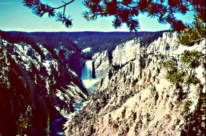
predominant during this stage. The picture at left is an example of what such a landscape might look like. It shows the V-shaped valley of the Yellowstone River and the falls of the Yellowstone River in the background. |
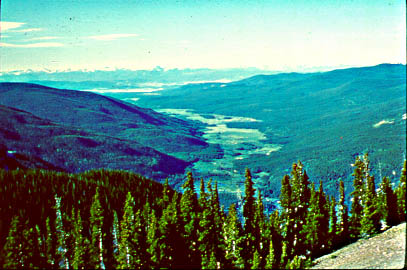 |
Intermediate Stage In this (mature) stage streams have thoroughly
dissected the former highlands, and the whole area is covered with a well developed
drainage network. The drainage divides are narrow now, overall the landscape is marked by
steep slopes that lead down to the stream channels. Gradually we approach a balance
between erosion and deposition. In the areas of the tributaries river gradients are still
steep enough to allow further incision, in the area of the main stream the slope is not as
steep any more, and the transport power of the stream is not large enough any more to move
all the sediment that is supplied from the tributaries. Thus some of this sediment is now
deposited on a flood plain in the main valleys (think of longitudinal stream profile
development). Thus the main stream begins to meander and sweeps across its valley (still
some erosion on the slopes [slope retreat] and cutbanks). The landscape consists now of
rolling hills between the tributaries, and a widening floodplain along the main stream.
Erosion is still larger than deposition during this stage. The picture at left shows a representative landscape in the Rocky Mountain foothills of Colorado. |
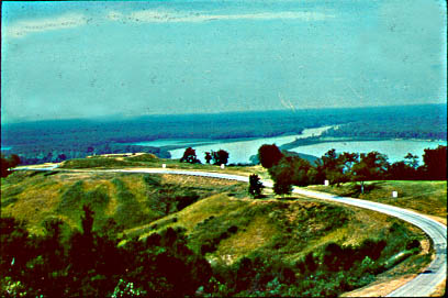 |
Late Stage In this (old) stage, as erosion continues and the flood
plains are widened by continued slope retreat, we finally reach a point where the slope is
so low that no net erosion occurs any more, and erosion on the slopes is balanced by
deposition on the floodplains. The hills are further reduced and the floodplains rise by
overbank deposition (flooding), until we finally end up with a landscape that is reduced
to a fairly featureless, flat surface that gently slopes towards the ocean. This surface
is also called a peneplain. From now on the rivers just sweep over the
floodplain and rework the sediment, creating various floodplain features, such as oxbow
lakes, meander scars etc. Isolated remants of resistant bedrock may rise over the
peneplain surface, the so called monadnocks or inselbergs. The picture at left shows a representative landscape of that type from the lower Mississippi Valley. The picture was taken from one of the remaining bedrock hills |
 |
When this linear course of landscape evolution is interrupted due to uplift, change in sealevel, or climate change, the erosive power of the rivers may increase again, and they begin downcutting through their previously deposited floodplain deposits. As they reestablish equilibrium after some time, they develop a new floodplain at a lower level. The river valley has been terraced. This process can occur repeatedly, and we can get a series of river terraces (or fluvial terraces) in a river valley. In a fashion, the landscape reverts to an earlier stage in its evolution (e.g. from intermediate/mature to the initial/young stage), and thus the process has been termed rejuvenation. Terraced river valleys are quite common, due to the strong changes of climate and sealevel in recent Earth history. Because the underlying processes are global in nature, episodes of river terraces can be used to correlate recent Earth history over large areas and even from continent to continent. |