Chapter 13: Evolution of Continents and Oceans
The theory of plate tectonics is nowadays more or less universally accepted by geologists, and I have mentioned the basic idea briefly at the beginning of this class. The basic thought is, that instead of being permanent fixtures of the earth's surface, the continents and ocean basins undergo continuous change. Both are parts of lithospheric plates that move against each other, and in the process new crust is created at midoceanic ridges (spreading centers), and old crust is consumed at convergent plate boundaries (subduction zones). Even before the theory of plate tectonics, there were a variety of geologic observations that suggested that the continents were on the move, but because nobody had a good idea what the underlying driving mechanisms might be, the idea languished in obscurity for the first half of the 20th century. For now we will take plate tectonics as a theory with a broad observational data base in its support, and will assume that it essentially works as outlined in Chapter 3.
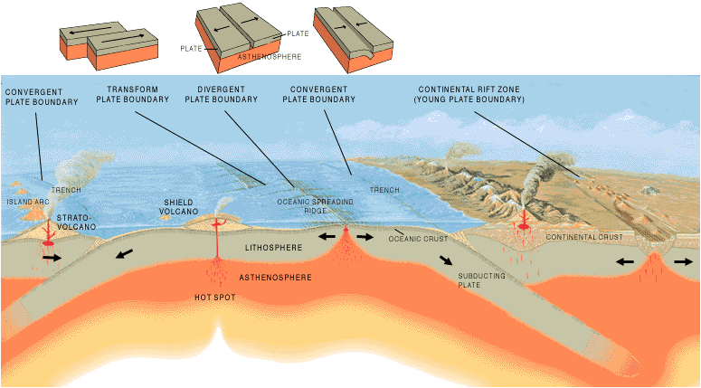
PLATE MARGINS
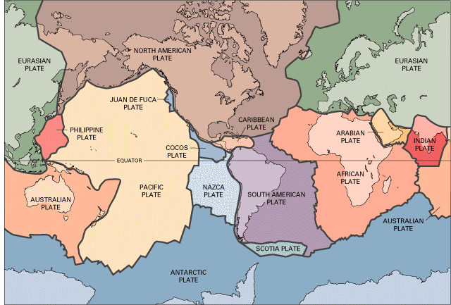
Alfred Wegener, the pioneer of continental drift, thought that the continents as plates move through the oceanic crust, implying thus that the shorelines of the continents are the margins of the continental plates. However, even though that may be initially a reasonable assumption (the shorelines being major geographic features), continental margins need not necessarily be plate margins. Today scientists have a fairly good understanding of how the plates move and how such movements relate to earthquake and volcanic activity. Most movement occurs along narrow zones between plates where the results of plate-tectonic forces are most evident. There are basically three different types of plate boundaries (divergent, convergent, transform), and a fourth type (boundary zones) is sometimes designated when it is difficult to define a clear boundary:
The three principal types of plate margins and various associated features are illustrated in the picture above.
Divergent Boundaries
 |
Divergent plate boundaries occur along spreading centers where plates are moving apart (white arrows) due to mantle convection and new crust is created by magma pushing up from the mantle. |
Perhaps the best known of the divergent boundaries is the Mid-Atlantic Ridge. This
submerged mountain range, which extends from the Arctic Ocean to beyond the southern tip
of Africa, is but one segment of the global mid-ocean ridge system that encircles the
Earth. The rate of spreading along the Mid-Atlantic Ridge averages about 2.5 centimeters
per year (cm/yr), or 25 km in a million years. This rate may seem slow by human standards,
but because this process has been going on for millions of years, it has resulted in plate
movement of thousands of kilometers. Seafloor spreading over the past 100 to 200 million
years has caused the Atlantic Ocean to grow from a tiny inlet of water between the
continents of Europe, Africa, and the Americas into the vast ocean that exists today.
The volcanic country of Iceland, which straddles the Mid-Atlantic Ridge, offers scientists
a natural laboratory for studying on land the processes also occurring along he submerged
parts of a spreading ridge. Iceland is splitting along the spreading center between the
North American and Eurasian Plates, as North America moves westward relative to Eurasia.
The consequences of this type of plate movement are easy to see around Krafla Volcano, in
the northeastern part of Iceland, and the Thingvellir Fissure Zone.
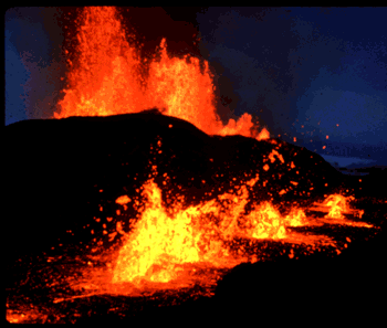 |
Lava fountains (10 m high) spouting from eruptive fissures during the October 1980 eruption of Krafla Volcano in Iceland. At Krafla, existing ground cracks have widened and new ones appear every few months. From 1975 to 1984, numerous episodes of rifting (surface cracking) took place along the Krafla fissure zone. Some of these rifting events were accompanied by volcanic activity; the ground would gradually rise 1-2 m before abruptly dropping, signaling an impending eruption. Between 1975 and 1984, the displacements caused by rifting totaled about 7 m. |
| Aerial view of the area around Thingvellir, Iceland, showing a fissure zone (in shadow) that is the on-land exposure of the Mid-Atlantic Ridge. Right of the fissure, the North American Plate is pulling westward away from the Eurasian Plate (left of the fissure). Large building (near top) marks the site of L�gberg, Iceland's first parliament, founded in the year A.D. 930. | 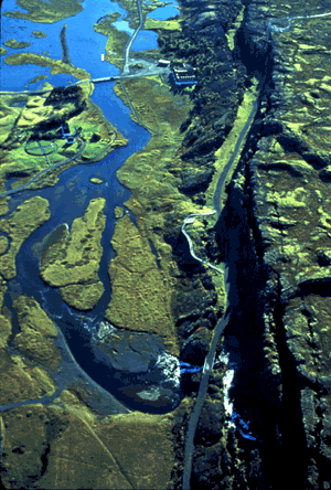 |
 |
The evolution of a divergent plate boundary has three recognizable
stages. The birth of a divergent boundary requires that an existing plate begins to
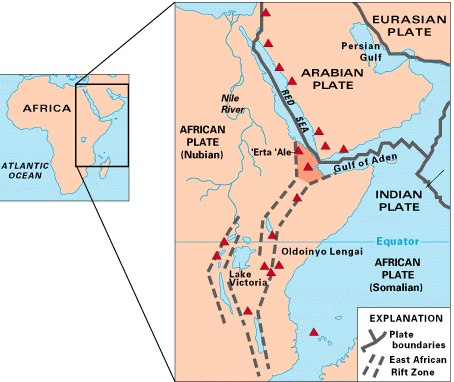
divide. This is happening today in east Africa, in an area known as the East African Rift
zone. The African continent is slowly splitting in two. As the continental crust divides,
magma from the asthenosphere fills in the gap. Several volcanoes are present in the rift
zone. Eventually the gap will form a narrow ocean (youth) much like the Red Sea to the
north of the East African Rift Zone. The Red Sea separates Saudi Arabia from Africa. East Africa may be the site of the Earth's next major ocean. Plate interactions in the region provide scientists an opportunity to study first hand how the Atlantic may have begun to form about 200 million years ago. Geologists believe that, if spreading continues, the three plates that meet at the edge of the present-day African continent will separate completely, allowing the Indian Ocean to flood the area and making the easternmost corner of Africa (the Horn of Africa) a large island. |
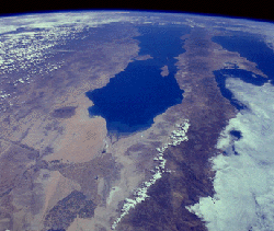
| A similar narrow sea, the Gulf of California (see image at right), lies between much
of Mexico and Baja California. The view to the south along the Gulf of California, between
Baja peninsula (right) and the mainland of Mexico (left). The Gulf is spreading, pushing
Baja further away from the Mexican mainland. It takes millions of years to form a mature ocean, as rates of plate motions are slow (10-100 mm/yr). At such rates it would take millions years to form even a narrow ocean. |
 |
Convergent Boundaries
The size of the Earth has not changed significantly during the past 600 million years,
and very likely not since shortly after its formation 4.6 billion years ago. The Earth's
unchanging size implies that the crust must be destroyed at about the same rate as it is
being created. Such destruction (recycling) of crust takes place along convergent
boundaries where plates are moving toward each other, and one plate sinks (is subducted)
under another. The location where sinking of a plate occurs is called a subduction zone.
The type of convergence (some call it a very slow "collision") that
takes place between plates depends on the kind of lithosphere involved. Convergence
can occur between an oceanic and a largely continental plate, or between two largely
oceanic plates, or between two largely continental plates.
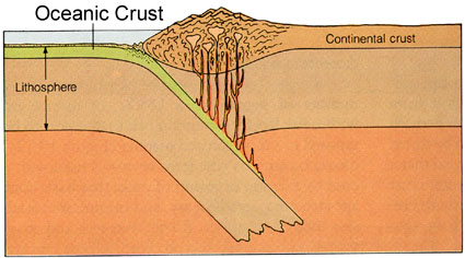
Convergence between continental and oceanic crust
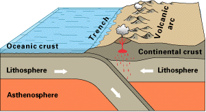 |
Off the coast of South America, along the Peru-Chile trench, the oceanic Nazca Plate is pushing into and is being subducted under the continental part of the South American Plate. In turn, the overriding South American Plate is being lifted up, creating the towering Andes mountains, the backbone of the continent. Partial melting of the subducted oceanic crust gives rise to andesitic volcanism parallel to the subduction zone. Because continental crust is less dense than oceanic crust, oceanic crust will always be subducted under continental crust. Strong, destructive earthquakes and the rapid uplift of mountain ranges are common in these region. Earthquakes are often accompanied by uplift of the land by as much as a few meters. |
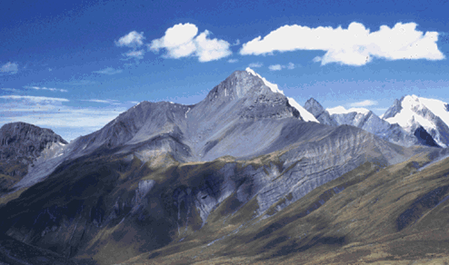 |
The convergence of the Nazca and South American Plates has deformed and pushed up
limestone strata to form the towering peaks of the Andes, as seen here in the Pachapaqui mining area in Peru. |
Convergence between oceanic and oceanic crust
 |
As with oceanic-continental convergence, when two oceanic plates converge, one is usually subducted under the other (the older one is subducted because of its larger density), and in the process a trench is formed. The Marianas Trench (paralleling the Mariana Islands), for example, marks where the fast-moving Pacific Plate converges against the slower moving Philippine Plate. The Challenger Deep, at the southern end of the Marianas Trench, plunges deeper into the Earth's interior (nearly 11,000 m) than Mount Everest, the world's tallest mountain, rises above sea level (about 8,854 m). |
Subduction processes in oceanic-oceanic plate convergence also result in the formation of volcanoes. Over millions of years, the erupted lava and volcanic debris pile up on the ocean floor until a submarine volcano rises above sea level to form an island volcano. Such volcanoes are typically strung out in chains called island arcs. As the name implies, volcanic island arcs, which closely parallel the trenches, are generally curved. The trenches are the key to understanding how island arcs such as the Marianas and the Aleutian Islands have formed and why they experience numerous strong earthquakes. Magmas that form island arcs are produced by the partial melting of the descending plate and/or the overlying oceanic lithosphere. The descending plate also provides a source of stress as the two plates interact, leading to frequent moderate to strong earthquakes.
Continental-continental convergence
 |
The Himalayan mountain range dramatically demonstrates one of the most visible and spectacular consequences of plate tectonics. When two continents meet head-on, neither is subducted because the continental rocks are relatively light and, like two colliding icebergs, resist downward motion. Instead, the crust tends to buckle and be pushed upward or sideways. |
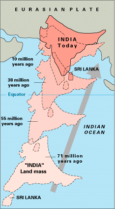 |
The collision of India into Asia 50 million years ago caused the Eurasian Plate to crumple up and override the Indian Plate. After the collision, the slow continuous convergence of the two plates over millions of years pushed up the Himalayas and the Tibetan Plateau to their present heights. Most of this growth occurred during the past 10 million years. The Himalayas, towering as high as 8,854 m above sea level, form the highest continental mountains in the world. Moreover, the neighboring Tibetan Plateau, at an average elevation of about 4,600 m, is higher than all the peaks in the Alps except for Mont Blanc and Monte Rosa, and is well above the summits of most mountains in the United States. |
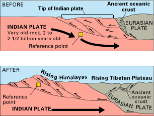 |
The collision between the Indian and Eurasian plates has pushed up the Himalayas and the Tibetan Plateau. The cross sections show the evolution of the Himalayas and the displacement of slivers of continental crust during this collision. The reference points (small squares) show the amount of uplift of an imaginary point in the Earth's crust during this mountain-building process. |
Transform Boundaries
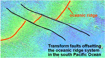 |
The zone between two plates sliding horizontally past one another is called a transform-fault boundary, or simply a transform boundary. The concept of transform faults originated with Canadian geophysicist J. Tuzo Wilson, who proposed that these large faults or fracture zones connect two spreading centers (divergent plate boundaries) or, less commonly, trenches (convergent plate boundaries). Most transform faults are found on the ocean floor. They commonly offset the active spreading ridges, producing zig-zag plate margins, and are generally defined by shallow earthquakes. |
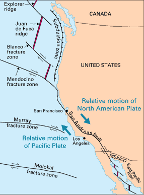 |
However, a few occur on land, for example the San Andreas fault zone in California.
This transform fault connects the East Pacific Rise, a divergent boundary to the south,
with the South Gorda -- Juan de Fuca -- Explorer Ridge, another divergent boundary to the
north. The Blanco, Mendocino, Murray, and Molokai fracture zones are some of the many fracture zones (transform faults) that scar the ocean floor and offset ridges. The offset that is marked by the San Andreas Fault also implies that there is mantle upwelling beneath Southwestern North America. The resulting extension is seen at the surface in form of a series of NE-SW trending mountain ranges and valleys, the so called Basin and Range Province, a result of Horts and Graben tectonics. |
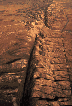 |
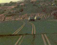
The San Andreas fault zone, which is about 1,300 km long and in places tens of
kilometers wide, slices through two thirds of the length of California. Along it, the
Pacific Plate has been grinding horizontally past the North American Plate for 10 million
years, at an average rate of about 5 cm/yr. Land on the west side of the fault zone (on
the Pacific Plate) is moving in a northwesterly direction relative to the land on the east
side of the fault zone (on the North American Plate). The picture at left shows and aerial view of the San Andreas fault slicing through the Carrizo Plain in the Temblor Range east of the city of San Luis Obispo. Other Pictures from the San Andreas Fault: |
Plate-Boundary Zones
Not all plate boundaries are as simple as the main types discussed above. In some regions, the boundaries are not well defined because the plate-movement and deformation occurs over a broad belt (called a plate-boundary zone). One of these zones marks the Mediterranean-Alpine region between the Eurasian and African Plates, within which several smaller fragments of plates (microplates) have been recognized. Because plate-boundary zones involve at least two large plates and one or more microplates caught up between them, they tend to have complicated geological structures and earthquake patterns.
 |
| Regardless of these complications, however, it is now a well established fact that the Earth's crust is broken into a dozen or so rigid slabs (called tectonic plates by geologists) that are moving relative to one another. |
The cause of plate movement is not accessible to direct observation. The various features of plate movement, and the increased heatflow along midoceanic ridges are consistent with the idea that plate movement is caused by convection in the mantle. The driving force behind the convection is heat generated by radioactive decay in the earth. The heat released by this decay (radiogenic heat) is transferred by convection (slow movement of hot, plastic rock) to the surface of the earth. Friction between the convecting mantle and the lithosphere (includes the rigid crust and that part of the mantle that lies above the plastic/soft behaving astheneosphere) causes the crustal plates (form the top of the lithosphere) to move according to the movement of the convection currents. Heat production in the earth will cease as radioactive decay diminishes, and then convection will cease and the final cooling phase of the Earth will begin. No more mountain ranges will be built, and the continents will become very flat. Eventually the oceans may cover the continents again (shallow seas, buildup of carbonate platforms, change of seawater composition because terrestrial input cut off, possibly a new stage in evolution). Tectonic movements will still occur, but this time they will mainly be a response to differential cooling of the earth (surface already cold, but interior shrinks now as well, volume reduction, pressure ridges will form due to shrinking, may resemble folded mountain belts).
THE OCEAN BASINS, THEIR EVOLUTION AND IMPORTANT FEATURES
Most of the earth's surface is covered by oceans, but for a long time the oceans have been an essentially white spot on the map of the world. Early expeditions like that of the Beagle (Charles Darwin) brought some preliminary knowledge, compilations of data by ship captains brought some initial knowledge about ocean currents and migration of fish swarms (mention Melville, Captain Ahab), but by and far we did not know much about the topography of the ocean floor, much less about its geological features. Starting at around 1930, however, a vast amount of knowledge has been gathered about the oceans, about their water chemistry, the cycling of elements, biological aspects, bathymetry, bottom sediments and their stratigraphy.
Though much less spectacular and not as well publicized, the progress in knowledge about the oceans is far more important for the future of mankind than to send a few men to the moon. Ocean research has implications for food resources, the supply of raw materials for a growing population, and possibilities of ocean population by man (giant raft cities in shallow seas, platforms moving with food-rich ocean currents, etc.). Even populating the deep sea is probably cheaper and more feasible than to have people live in colonies on the moon.
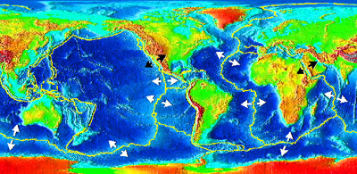
Work on the bathymetry of the ocean basins (mainly with echo-sounding devices) has revealed many morphologic features that were previously unknown, such as oceanic ridges, abyssal plains (and hills), seamounts, trenches, and continental margins, all of these features are now easily explained by plate tectonics.
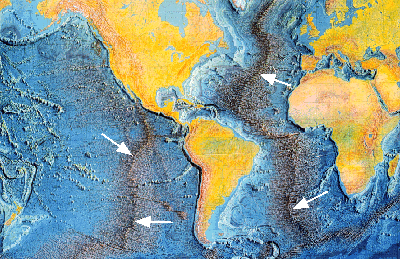 |
Map of the Atlantic and Eastern Pacific Basin. Mid-Oceanic Ridges (marked with white arrows) are extensive. These are the youngest portions of the ocean basins where new ocean crust is generated through mantle upwelling and plate divergence. Taken together the oceanic ridge system of the earth is about 65000 km long and extend all around the globe. |
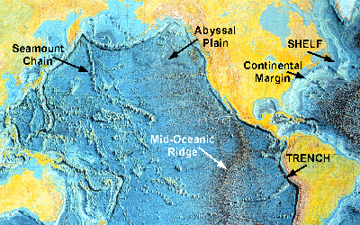 |
Map of the Pacific Basin and parts of the central Atlantic. Continental
Shelf = flooded edges of the continents; Continental Margin =
the edge/border region of the continent; Deep Sea Trenches = deepest
parts of ocean basins (due to subduction of oceanic crust); Abyssal Plains
= older parts of oceanic crust, smoothed due to sediment deposition; Seamounts
= submarine volcanic cones; the can also form linear arrangements, so called Seamount
Chains. Continental margins are in a geological sense not part of the oceanic crust. They consist of continental crust and material that was eroded from the continents and is now piled up along the margins of the continents. The margins are subdivided into CONTINENTAL SLOPE and SHELF with the latter simply being a submerged part of shield or platform. |
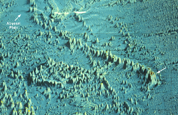 |
| Closeup of central Pacific Basin. Shows how the Hawaiian Islands (Hawaii marked with white arrow) are the youngest portion of a long chain of seamounts. The linear arrangement of many seamounts indicates that they formed because the plate moved over a stationary site of magma upwelling, a so called mantle "Hot Spot". Seamounts are submarine volcanoes that may finally build above the water level (e.g. Hawaii), in which case they are called islands. If seamounts rise above sea level (rises for two reasons, buildup of material in a cone, upwelling mantle pushes up plate), they are subject to wave erosion and colonization by reefs, with both processes tending to create a flat top on the original volcanic cone. Later, when the oceanic plate cools down and the island finally drowns we get flat-topped seamounts, so called GUYOTS. |
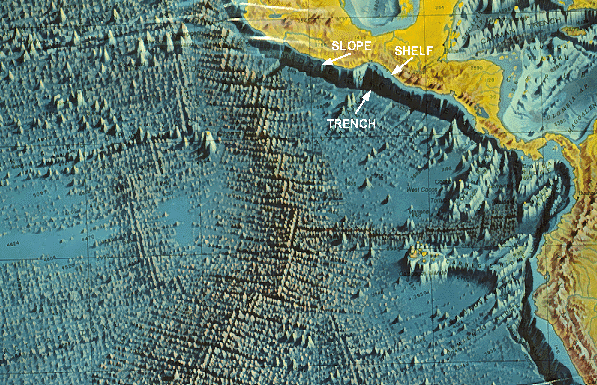 |
| Closeup of the eastern Pacific Basin. Shows triple junction of spreading ridges in center. Also shown are the subduction zone/trench along the western edge of central America, and the associated slope and shelf regions. The trenches are the deepest parts of the oceans and are the topographic expression of subduction zones. They are marked by intense volcanism (island arcs, volcanic mountain ranges, e.g. Andes, Cascades), and high frequency of earthquakes. hey are usually asymmetrical with a gentle slope towards the subducted plate, and a steeper slope towards the subducting plate. Some trenches are as deep as 11 km, and may extend for thousands of kilometers across the seafloor. |
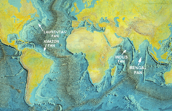 |
| A map of the ocean basins where the locations of some major deep sea fans are marked.
Deep Sea Fans are large sediment accumulations that are deposited
on the slope and the adjacent seafloor. The sediments are supplied to the slope
regions through submarine canyons, deep incisions in the continental
shelf that probably originated during prior episodes of low sea level (ice ages). Along
the continental margins sediment that is conveyed to the deep sea via submarine canyons
(sliding, mass movement, turbidity currents) forms large cone-shaped or fan-shaped
sediment accumulations at the toe of the continental slope, so called SUBMARINE FANS or
DEEP-SEA FANS (not unlike alluvial fans). Turbidity currents move down these fans, spread
out on the abyssal plain, decelerate, and deposit graded sand and silt layers (so called
turbidite sequences). Sediment spreading by turbidity currents helps to smoothen the
relief in abyssal plain regions. The floor of the ocean basins (abyssal plains) is essentially basaltic crust that is covered by sediment (settling from suspension, of organic material such as foram tests, radiolarian tests, etc., and also clay swept in from the rivers, volcanic ash [large ashclouds may circle the globe several times], and material transported by winds from the continents [Atlantic west of Sahara desert]). We call that material PELAGIC SEDIMENT. |
COMPOSITION AND STRUCTURE OF OCEANIC CRUST
The oceanic crust is not simply a pile of basalt, but can be subdivided into several distinct layers, that form in response to the processes operating at a midoceanic ridge.
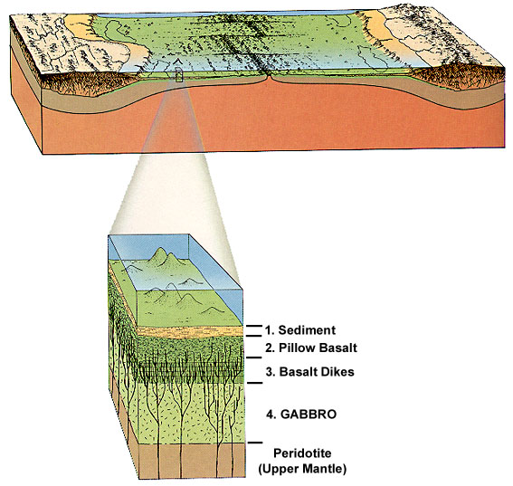 |
The top layer (1.) consists of pelagic sediments that were deposited above the basalts of the oceanic crust. The second layer (2.) consists of lavas that were extruded onto the ocean floor at the spreading center. These lavas are called pillow basalts, because of the way they appear in cross-section. The molten basalt is extruded onto the ocean floor through fractures (extension), and as soon as the molten material comes in contact with seawater it will cool down and solidify. The next batch of lava will come out to the side of the first one, and also will solidify, etc. We will slowly pile up small batches of magma, that in their geometric arrangement are not unlike a pile of sausages, or squirts out of a toothpaste tube. In cross section we will have mainly elliptical cross-sections (pillow shape), thus the name pillow basalt. The surface topography of this layer is irregular and rough. The third layer (3.) consists essentially of complexly cross-cutting, near vertical basaltic dikes, which are the feeder channels for the pillow basalts. They form as fractures at the spreading center (highest extensional stress), and finally fill up with basalt and become part of the sheeted dike complex as they move away from the spreading center. The fourth layer (4.) consists of the magma chambers that feed the dikes of layer three, and these leftover magma chambers are filled by the plutonic equivalent of basalt, gabbro. The magma itself originated by partial melting in the mantle below the spreading center (higher heatflow, rising of accumulating melt). Below that layer is the mantle (asthenosphere), consisting of peridotite. |
That the oceanic crust is layered has been known from seismic refraction data, but nobody has ever drilled through the oceanic crust (too hot). Fortunately, once in a while bits and pieces of oceanic crust are incorporated into the uplifted material of flooded mountain belts, and is thus available for direct and detailed study. In Iceland, where the Mid-Atlantic Ridge rises above the sea surface, is another opportunity to examine the structure of the oceanic crust.
As new oceanic crust forms at mid-oceanic ridges, cold sea water invades the hot new crust through the abundant fractures (crustal extension). As the sea water heats up its density decreases and it rises upwards. When it leaves through fractures at the seafloor we have submarine hot springs, better known as black smokers. These hot springs have created quite a bit of excitement in the scientific community because they open up all sorts of unexpected angles on the chemistry of the oceans, the transfer of chemical elements between the oceans and the oceanic crust (elemental cycles), and the origin of life. The latter was prompted by the discovery of unusual communities of microbes, worms, clams, and crustaceans that live at hot spring sites and instead of sunlight depend on energy supplied by the hot springs in the form of sulfides.
EVOLUTION OF CONTINENTS
The characteristic features of continents are shield areas, stable platforms, and folded mountain belts (introduced earlier in this lecture). With the theory of plate tectonics we can now relate these features to each other and describe them as different phases in the evolution of continents.
 |
When we examine the continental crust in some detail, we see that in many areas (e.g. Texas) it consists of a thin surface cover of horizontally stratified sediments that is underlain by complexly deformed metamorphic rocks that have been intruded by granites. In places where vast areas of this lower complex of rocks are exposed, we speak of a "shield". In places where the shield material is covered by sediments we speak of a "stable platform". This kind of situation is typical for large portions of continents, except along some of the margins where we have subduction and compression. In the latter case mountain ranges develop end we have "folded mountain belts". |
Pertinent features of the continental crust are:
SHIELDS contain the bulk of the rock record of continental evolution and growth, and are thus the key to the understanding of the origin of continents. As noted earlier, they are essentially flat and consist of a complex arrangement of igneous and metamorphic rocks. The mere fact that these rocks are exposed at the surface now, implies that many kilometers of rock were eroded from the continent before these rocks finally came to the surface. If the shield rocks of a continent are studied with respect to their metamorphic age, it often turns out that those on the center are the oldest ones, and that there are several belts of metamorphic rocks that get progressively younger outward. The oldest portions of the shields consist of a mixture of volcanic rocks (basalts, andesites) and volcanic derived sediments (erosion of volcanoes), and the rocks show similarity to the material accumulating in modern day island arcs. Only when these basically mafic rocks were later on intruded by granites, did the overall composition become granitic (75% granite). Later metamorphic belts were accreted onto these old continental cores (will discuss a little later) and have overall a considerably more granitic composition (because the sediment was derived from a crust that was already 75% granite).
STABLE PLATFORMS As time goes by, the shields are eroded down to within a few tens of meters of sea level, and any rise of sea level will lead to flooding of vast areas of the shield (plate tectonics, increased spreading, rise of ridges, flooding). At present only 18% of the continental crust is flooded, but there were times in the past where vast portions of the continents were covered by a shallow sea (interior of North America).
FOLDED MOUNTAIN BELTS are usually found along the margins of continents, and the folding and thrusting indicates that as much as 30% of crustal shortening has taken place during their formation. We know now that his shortening is a direct reflection of the compressive stress regime and subduction of oceanic crust along convergent plate margins, but before plate tectonics the missing crust was very troublesome thing to explain. The location of these fold belts along continental margins implies that by convergence of plates material is piled up along the continents, and finally becomes part of the continental crust. Fold belts that are terminated abruptly at the continental margin, such as the Appalachians and the Caledonides, suggest that he fold belts were once much longer, and have been separated when continents broke up by continental rifting.
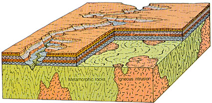
From Mountain Belt to Continent
 |
When a mountain belt is formed along a continental margin by subduction, sedimentary and volcanic rocks are buried deeply and undergo high-pressure and high-temperature metamorphism in the root zone of the mountain belt. Also, parts of the buried material as well as of the subducted oceanic plate melt, and granitic and andesitic magmas rise. A considerable portion of the granites never rises to the upper portions of the mountain range, and crystallizes within the realm of the metamorphic rocks in the lower portions. |
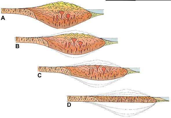 |
The newly formed mountain range (A) is of course in isostatic equilibrium with the mantle (that's why we have a root zone), but as erosion wears down the top portions of the fold belt, the root zone has to rise in order that equilibrium is maintained (B&C). In that way the volcanic and sedimentary unmetamorphosed portions of the range are eroded away, and the metamorphosed and granite intruded lower portions move upwards (B&C). This process continues until the fold belt is eroded down to sealevel, then erosion stops and isostatic uplift ceases (D). By that time the outcropping rocks will be the high grade metamorphics and granites of the root zone. We started with a folded mountain belt, and through continued erosion we have produced a new piece of shield material. |
Formation of a fold belt and a metamorphosed root zone on convergent plate boundaries is also known as orogeny (or creation of mountain ranges). Within the context of different types of plate convergence (mentioned earlier) we can distinguish three different main types of orogeny (ocean/ocean = island arc; ocean/continent = fold belt/volcanic arc; continent/continent = fold belt/high plateaus).
EVOLUTION OF A CONTINENT
We can use these different types of orogenies and the underlying plate tectonic processes to explain the evolution of continents and the continental crust.
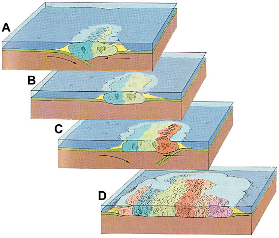 |
Initially (A) we might for example have only oceanic crust, convergence of oceanic plates and formation of island arc complexes (andesitic material, too light to be again subducted). Sediment is shed from the arc (B), is compressed and pushed against the arc, the mountains rise, and the root zone grows, until finally high-P/T metamorphism and granite plutonism occur (C). We start accreting material (folded mountain belts) to the initial arc, an embryonic continent is formed (C). The continent is eroded and quartz, feldspar, and clay-rich sediments accumulate around its margins. Renewed subduction pushes up new folded mountain belts, accompanied by metamorphism and granite plutonism. Finally the new fold belt is worn down and another segment has been added to the growing continent (D). Continued accretion etc. etc., the cycle repeats and the continent grows (D). |
Crustal recycling and the differentiation of the continental crust is intimately related to the composition of the oceans, the supply of nutrients for the global biomass, and thus is also linked to those global feedback mechanisms that we consider essential for climate regulation (carbon cycle etc.). In part, the biosphere has adapted opportunistically to whatever chemical components were provided in the process, but it also has an active role through the weathering of continents, the deposition of carbonate banks, the carbon cycle feedbacks with climate, etc.
I hope that in the course of this lecture you have gained insights into three topical complexes:
Eventually, all things merge into one, and a
river runs through it.
The river was cut by the world's great flood and
runs over rocks from the basement of time.
On some of the rocks are timeless raindrops.
Under the rocks are the words, and some of the words are theirs.
I am haunted by waters.
Norman Maclean, from "A River Runs Trough It"